Feeds:
Posts
Comments

Archive for the ‘bridges of the Tees’ Category

I always knew this was going to be a longtime series, but it seems it was May 2017 when I last posted something on this project.

Quick recap: I’m visiting all the crossings over the River Tees in North East* England, from source to sea. I’m interested in the role of the river in the landscape generally but also how people have sought to get from one side to the other and why. It’s a long and fascinating history of people in their landscape, and I don’t think there’s another river with such variety and heritage as the Tees. Also, it’s where I live. So far I’ve done five of them – four bridges and a dam wall and they’ve all been in order. I’ve since visited another three with the intention of posting about them, but for some reason I hadn’t actually done so. I’ll probably go back and revisit these before posting them to refresh my memory.

So, being that quiet time between Christmas and New Year, and armed with a new pair of walking boots, I decided to explore another couple of bridges on the route. To confuse things a little, they’re further downstream than I’d got up to. And I did them in reverse order. But it’s two more off the list..

I live in Upper Teesdale – where the river is wild and the centre of the landscape as the fells all roll down to the river at the bottom of this long and narrow valley. It’s very rural and very remote – there are no shops and even the nearest pub is a good couple of miles away across the fields. So to get anything I generally have to drive a fair way.

Barnard Castle is not a place I really know that well. It’s the nearest market town, but it’s not that big. I only ever go to Barnard Castle because I have to, not because I want to. It’s not far enough to be exotic or a day trip, and not big enough to be the solution for all the complicated things I need that I can’t get locally, so I really don’t go there that often. So the bridges of the Tees seemed a good excuse to go and discover bits of the town I didn’t know.

APC_0181.JPG

I started at the Bowes Museum – one of the few reasons I go to the town, and mostly because of work, but as local museums and art galleries go, it really does take some beating and I know I’m really lucky to have such a place on my doorstep.

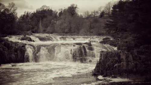
A short stroll across the road between the old vicarage and another large victorian country house you find yourself in the open fields of the Demesnes. These were the fields owned by the lord of the castle for his own use rather than tenanted farmers. They’re now an open space for the use of the people of the town. The well trodden footpath leads down behind the waterworks to the river. Here the river is wide and shallow and skips over small rocks scattered across its width. The route of the river is through a shallow gorge with occasional bare rock cliff faces. Very quickly you are out of the town and into open countryside and it’s all very tranquil.

L1210681.jpg

L1210705.jpg

L1210688.jpg

Soon you get a first glimpse of the ruins of Egglestone Abbey on the other side of the river. Here the river gets rockier and more turbulent as it narrows. There are the remains of the Abbey Mill footing into the water on the far side. A short wooded slope brings you up to the top of Abbey Bridge.

L1210722.jpg

The steep woods around the bridge make it hard to get a good look at the single stone arch itself, but being the middle of winter, it’s also the time for seeing glimpses through the bare foliage.

L1210727.jpg

The bridge itself is a sturdy affair – it’s the diversionary route for vehicles too heavy for Barnard Castle bridge and Whorlton Bridge either side and has the battle scars of the wagons too big for the sharp turn onto it as a result.

The bridge was built in 1773 by the Morrits of nearby Rokeby (yes, that Rokeby – Turner, Walter Scott etc.) who wanetd better access from their estate to Barnard Castle. A single track crossing, it has distinctive castellated parapets and refuges above the arch pillars. On the south side are two octagonal enclosures – the remains of the toll booths in use up until the 1950s.

L1210735.jpg

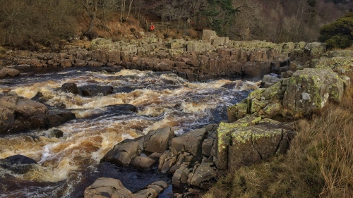
It’s a very high bridge with good views of the river from the top as it passes in a rocky and turbulent gorge beneath.

L1210734

Crossing the bridge, I turned back on the other side, past the impressive 12th Century ruins of Egglestone Abbey up on its rocky vantage point. Beneath the foot of the abbey the road crosses a small beck beside the river. This was originally a ford and the 17th century packhorse bridge sits beside it. Still in great condition, but too steep and narrow for cars.

L1210758.jpg

The footpath leaves the road when it deviates away from the river and crosses a handful of fields above the wooded gorge. Again, the leafless trees giving glimpses of the landscape beyond.

L1210780.jpg

The trail passes through a caravan park on the banks of the river. There’s something quite surreal about these places – like an out of place suburbia existing in its own well ordered world. The footpath quickly reaches the outskirts of the town and the mill buildings along the rivers edge to the north.

APC_0177

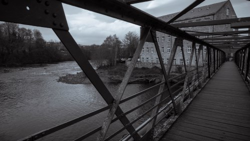
Thorngate Bridge is a long, green iron girder bridge spanning the shallow and wide river on the exit of a sharp bend. Built in 1881, the bridge replaced a lightweight three span bridge on the site that was washed away within 10 years. Before that the shallow river was crossed at this point by stepping stones.

L1210788.jpg

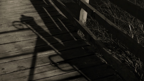
Thorngate Bridge is in three spans on two short pillars. The main span in the centre being over 50m long. The bridge remains largely unaltered from the day it was built – a very utilitarian footbridge made from steel and cast iron girders with a wooden walkway. The lamp brackets at either end are now empty and were the only source of illumination. The bridge was built to enable workers from the Yorkshire side of the river to get to work in the 19thC mill on the north bank.

L1210791.jpg

The wool industry was a major part of the town of Barnard Castle. Beyond the Victorian carpet mills down by the river,Ā  the short walk back up Thorngate passes some of the most fascinating 17th and 18th C houses with their weaving loft windows up on the top floors.

L1210805.jpg

It’s been interesting to explore somewhere I kind of know but don’t really know. There’s another 4 crossings around the town which I’m looking forward to discovering and getting more familiar with. Barnard Castle is also the outer limit to what I consider to be ‘local’. Beyond the town the landscape is very different and the route goes to places that are mostly new to me. Hopefully it won’t be another another 18 months before I do more exploring.


*technically the river Tees starts in Cumbria which is technically in the North West, but borders are a bit vague here…

Read Full Post »

I am already getting so behind in this tale. I set off weeks ago in all good faith half expecting to be at Barnard Castle by Easter. That hasn’t happened. While I’m more advanced in my journey than this blog would suggest – for those who follow me on social media will have seen I’m three bridges further on already – the annual awakening by people who want me to work with them has started and the day-to-day projects are almost at full capacity.

However, it’s a well-earned weekend off so I can pick up on where I was and start to clear the blog post backlog before I venture any further and make it worse.

In the previous post we’d got as far as Holwick Head footbridge. We’re now on very familiar turf. The next two stretches are very much my regular walking patch. It’s where I go most often when I need to get out to walk and think – or sometimes not think – frequently just as useful.

This is a well worn part of the Pennine Way and extremely popular with families at weekends. The while most set off from Bowlees to walk up past Low Force to High Force, a fair few will call it a day at Holwick Head, or head over the river to lunch at the High Force Hotel.

The river on this next stretch is always reasonably fast and it’s one of the steepest downhill stretches. Every hundred yards or so there is another little cataract or cascade helping it lose height. This stretch is also populated by a number of islands. When the river level is low, most of these are accessible from the south side. Some of the islands are barely separated from the bank, others are at points where the river splits and flows around them. The largest islands are separated by deep gullies which flow back up from the downstream end leading to a false sense of a very calm and flat river, when in reality on the far side of the island the river course is crashing down a series of violent falls with deep pools and jagged barricades of whinsill.

File 30-04-2017, 19 44 08.jpeg

On the day I walked to photograph it for this blog post the river was in full spate. A recent sharp thaw along with a day’s rain had really swollen the river and it was galloping along at a frightening pace. Leaping over every rock and boulder that still broke the raised water surface.

The largest of these cascades is Low Force. Here the river falls over a series of small drops before committing itself to the main 8m (24ft) fall.

File 30-04-2017, 19 42 48

Low Force is actually two main fall paths – the main one to the left is bisected by a stubborn Ā outcrop at the top dividing an otherwise continuous drop to a deep pool beneath. Only when the river is in spate does this fall take on the full grace of a seamless curtain or river. To the right another gap in the whinsill allows another deeper but narrower column of water to escape. The volume of water through this narrower opening makes for a much more powerful spout that frequently carries rainbows in its spray in the late afternoon. Further across the river is another of the occasionally isolated islands. This one is accessible from the north bank for most of the summer months and gives a great view of the falls from the other side of the river. In the winter months this island is separated by a shallower stretch of river which in turns cascades into a an elongated still pool just downstream of the main falls.

Today the falls were in full flow and Low Force was mostly one giant wall of water charging over the sill. The waters below were deep and dark and constantly swirling with a menace of unseen currents.

File 30-04-2017, 22 37 01.jpeg

Downstream of the falls a particularly impressive outcrop of the now familiar doleriteĀ columns act as a perfect picnicking spot with classic romantic views of the waterfalls through the trees in the woods beyond.

Low force is a popular spot for visitors and locals alike. The accessibility of the waterfalls and myriad of revealed views give a very real impression of the power of the river at this point. Weekends see often large number of people coming to look in awe and wonder. A beauty spot I guess some would consider it.

File 30-04-2017, 19 17 07

Kayaking over Low Force on a sunnier day

Some get even more acquainted with the forces of nature. Most weekends in the spring and autumn when the water levels are up Low Force becomes a major attraction for kayakers, whitewater rafting or sometimes river rescue training. From Holwick Head footbridge to the sea at Redcar, the Tees is navigable all the way in a kayak. Only during extended periods of dry weather does the stretch down to Middleton in Teesdale become a problem when the rocky nature of the river bed and its dark water prove to be too difficult.

File 30-04-2017, 19 35 05

Just below Low Force the river is crossed by the first of the genuinely interesting bridges – Winch Bridge. Originally built in the 18th century to allow lead miners in Holwick village to get to the newer workings above Newbiggin the first bridge is thought to have been the earliest example of a suspension bridge in Europe. The original bridge was made from hand wrought iron chain links with a single handrail across. In 1802, during a bad storm, three people were crossing the bridge when it gave way and all three were plunged into the raging water beneath. Two were rescued but the third was swept away to his death.

File 30-04-2017, 19 21 14

The bridge was rebuilt in around 1830 and that is the form it takes today – two spans of cast iron chain with a timber walkway between. It has a handrail on each side suspended from cast iron towers on either side. Some additional strengthening was made in 1990, but it’s essentially the same 1830 suspension bridge and sways a fair bit when crossing.

File 30-04-2017, 19 20 19

It’s a good place for a bridge. The rock faces either side make the river narrow so a short crossing. The density of the whinsill make it a very stable base to anchor a bridge. With the river running so fast on this stretch, bridging the river was a much safer option than fording it. A suspension bridge is a really good design solution for this site, but I wonder, given that this was probably the first suspension or chain bridge in Europe how the miners arrived at this solution in the first place. Even this 1830’s rebuild is an elegant solution and one that’s clearly stood the test of time. With its footings well above the waterline, this is the bridge that so far has lasted the longest in the upper reaches of the river.

The steep chasm below and the dark, swirling waters add to the sense of drama of this bridge. That combination of foreboding rocks, black water and the height above them being crossed with something as light and delicate and a few plank of wood suspended between thin pillars that makes this a memorable crossing.

File 30-04-2017, 19 36 02

But there’s still another 50 miles or so to go before we reach the sea and there are many more ways that people have found to get across this river. From the centre of Winch Bridge you get a great perspective of the river turelessly working its way ever onward.

Read Full Post »

The curlews are back.

As a phrase it’s simple and short. You can pack so much into short phrases. In Shakespeare’s ‘King Lear’, the pivotal moment in the whole play is written as just ‘He died’. There’s no how or why or wherefore. No big announcement or speech. No high drama. Just two words.

The curlews are back.

it’s four words, granted, but in the upper reaches of the North Pennines it says so much. In any normal winter it would mark the end of it. A return to normal and the reassurance that everything will be OK again. With the numbers of curlew and lapwing and oystercatcher and redshank on the ever decline in the North of England, it marks something of a sigh of relief to hear those first whirring, bubbling, almost alien calls echoing around the fells.

Hearing those sounds also reminds me I’m in the Upper Dale, which is where I got to after leaving Cronkley Bridge. Heading ever onwards, downstream towards the distant sea.

Today the river level is up a bit and the water is running at a fair pace. Not quite in spate, but in a decided hurry nonetheless.

Following the Pennine Way, the path is well marked and maintained, but moves away from the course of the river as it swings right and left and right in big sweeping curves beneath Dime Holm Scar. Up on Bracken Rigg the path flatten out to a brief plateau and the gentle mounds of a bronze age settlement.

The path next meets the river just before the crushing plants of High Force Quarry loom up on the opposite bank. A still very active whinstone quarry, it’s a present reminder of the industrial activity that’s shaped all of the landscape around here. This now barren and wild landscape bears the marks everywhere of centuries of mining and quarrying and the wealth and poverty of those that came to make their fortune from what lies beneath the surface.

File 12-03-2017, 20 23 38.jpeg

But the landscape is vast too, and easily swallows up the industrial workings. A mere dot on the wider view.


And opposite, barely visited and overlooked by the rumble of machines and steel and rubber tyres, is one of the most spectacular waterfalls in this part of the Pennines.

File 12-03-2017, 20 45 09.jpeg

Bleabeck Force is the final leap where two becks from way up the fell meet and tumble down in a race to get to the river. From the Tees there is a small concrete beam bridge that gives you a view up the lower cascades and the top of the highest one. A short scramble over the boulders rewards you with a great view of the main fall and plunge pool below. The water levels on these fellside becks and gills are fickle and I’ve walked past this many times and never seen it look quite so spectacular. I’ll definitely make the journey up on a spate day.

File 12-03-2017, 19 24 42

Back at the Tees, the river is still in a bit of a hurry. Skipping over the rocky bed which itself is becoming increasingly jarred and jagged with much larger outcrops appearing to grow up from the river bed. These angular intrusions breaking up the flow of the river and churning it white and chaotic.

File 12-03-2017, 19 47 13.jpeg

A quarter of a mile further on the river meets a wall of whinstone and is forced into a narrow channel down one side. The full width of the river – maybe 10 metres or more squeezed into a gap no more than a metre in places. here the water shows it’s true potential. You sense it’s speed and sheer will power.

File 12-03-2017, 20 24 57.jpeg

It’s sprinting now.

File 12-03-2017, 19 34 34

Then with one last twist and pirouette it leaps.

File 12-03-2017, 19 32 32

and over a 35m vertical drop. In one, two steps.

As it collides with the pool below, large quantities launch back up against the incessant downforce.

This is High Force. The ‘biggest’ waterfall in England. I’m not sure how they quantify these things. It’s not the highest or the widest, but when in full flow it certainly has the largest volume of water per metre drop. Or something like that. Well, it’s impressive and it’s the biggest tourist attraction in the upper dale.

There’s two ways to see this. From the carpark beside the High Force Hotel on the main dale road there’s a very attractive path that leads down the steep gorge to the base of the water falls for a few pounds entrance. Here you get to be as close as you’d want to get o experience the full power of the falls. When it’s in full flow the spray can be so much it’s difficult to see the falls. But the sight of that much water in full motion and the continuous roar is a real experience.

Alternatively, from the Pennine Way on the other side of the river, you can get scarily close to the very top of the falls and watch the water disappearing down to the river below. Further downstream, there’s a little path off the main route that takes you to a small, unmarked viewing clearing where you get to see the whole waterfall in it’s full glory. And this one is free.

File 12-03-2017, 19 31 16

Breaking yourself away from watching the waterfall, the path continues through a very ancient juniper forest while the river runs through a steep wooded gorge below and largely unseen for about a mile. The path meets the river again at the next bridge.

File 12-03-2017, 19 23 42

It’s bridges we’ve really come to see and this is a fine one. Holwick Head Footbridge links the main Teesdale road with Holwick Head HouseĀ and the track down towards Holwick village and the Earl of Strathmore’s estates.

File 12-03-2017, 19 28 44

Upper Teesdale is split into two major estates – to the north is the Raby estate of Raby Castle and the ownership of the Lord Barnard. It can be distinguished by its whitewashed buildings and dark blue paintwork. To the south of the river at this point is the estate of the Earl of Strathmore who has a country house at Holwick Lodge. Holwick Head Bridge marks a link between the two estates and was originally built by theĀ then Duke of Cleveland in 1896 and was known at the time as the Duke’s Bridge.

File 12-03-2017, 19 29 31

It was rebuilt as a single footbridge by Durham County Council in 1998, but still retains the rather grand cast iron gateposts of the original bridge made by Motley and Green of Leeds.

File 12-03-2017, 20 26 21

It’s a simple steel girder construction over a central stone pillar with wooden decking. It’s a popular bridge with walkers making circular trips along the river, or just as a stopping place to stand and watch the river run below. But its still only a footbridge. The first proper road bridge across isn’t for another six or seven miles yet which makes you realise just how isolated the south side of the river is. These bridges may be few and far between, but they’re vital for getting around this landscape.

File 12-03-2017, 19 30 21

From the top of the bridge the river is busy on its way and largely ignores the passing of people overhead. It may have lost some of its width since High Force, but it’s lost none of its sense of purpose. There’s no slowing down or pausing to catch a breath. It will need all its energy to get past the next bit.


Read Full Post »